Monday 18 June 2007

June: A Riverbank Walk to Brockholes

On a hot sunday in early June (luckily before the awful cold and wet weather we've had since!) we walked from Penwortham Old Bridge upriver to Brockholes Wetland.


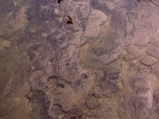
The tide was out and very low, the beautiful contours of the prehistoric riverbed clearly visible in the clear waters...


... large numbers of assorted Riversiders are out enjoying the peace and tranquillity of the Ribble riverbanks as we pass along the Penwortham Green Belt...


... and a large number of riversiders are right down by - and even in - the water, relaxing and playing as the Ribble's cool waters flow by...


...at Walton le Dale the Ribble's waters sparkle in the hot sunshine, and there are numerous birds singing all around...


...and we negotiate a passage through the other riverside residents who come over for a chat.

One of the many spectacular things this stretch of the Ribble - from the Shawes Arms at London Road (A6) right through to Brockholes and for miles beyond - are the huge numbers of Sand Martin colonies in the soft riverbanks. These graceful but incredibly fast birds are all around us, skimming over our heads and across the water catching small insects for their chicks...


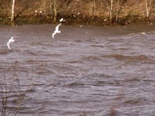
...and all along the river we meet a variety of wildlife, all enjoying the range of habitats the Ribble provides, from fish moving lazily in the shallow pools or jumping for flies on the surface of the water, to birds flying overhead, or feeding and snoozing on the river...


The view up towards Brockholes at Mete House is glorious - and resonant of old paintings of the Ribble, showing how remarkably unspoilt the Ribble's valley is...


River Ribble circa 1862 by Thomas Lynch.

...we are lucky enough to catch glimpses of several Kingfishers all the way along the walk, although, like the Martins, Swallows, and Swifts, they are so difficult to catch on camera...


but if you click on this picture to enlarge it, you'll see a flash of blue where one is sitting in the bare branches above, on the right of the picture.

Out of the hot sunshine and into the dappled shade of Mellings Wood is a great pleasure...


...and out the other side we see a couple of Herons, one of whom is just as interested in us...


Once we reach the section of the Ribble Way which runs through the centre of the new reserve at Brockholes Wetland (Higher Brockholes Farm, as was), we are blown away by the vast numbers of Damselflies who are literally all around us...


We feel that this part of the Ribble Way should be renamed Damselfly Way!


We stop and sit on a grassy bank overlooking the largest lake on Brockholes Wetland (which is also the oldest of the quarried lakes here so its habitats are becoming well established).


We are surrounded by various caterpillars so have to be careful where we sit!


Brockholes Wetland is already a fantastic place, so it will be amazing when the Wildlife Trust have improved its habitats. This wetland is also bordered by the ancient woodlands of Red Scar Wood and Boilton Wood.


After a good long relaxing rest and the copious amounts of the water we brought along, studying the many insects, Damselflies - and even tiny furry creatures scuttling through the long grasses - we stir ourselves and head back downriver, knowing that the journey back home will be just as brilliant.


We pass back through Lower Brockholes Farm, a beautiful ancient farmland bordered by species-rich wet grasslands and the ancient deciduous woodlands of Brockholes Wood.


Speedwell glows amongst the long meadow grasses at Lower Brockholes Farm.

Unfortunately, however, this is the last days for Lower Brockholes Farm as it too is to be quarried for aggregate, so this landscape will soon change forever...


If its afteruse can also eventually complement the Ribble's wetland habitats, then it won't be so bad, so we hope that this will indeed be the case.

We pass other riversiders on the way back downriver too...


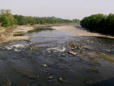
The Ribble is recovering from many years of misuse and pollution to become one of the best Salmon and Trout rivers in Britain,

and spawning pools in the numerous gravelly shallows of the riverbed are one of the reasons why.


In some areas these spawning pools have been deliberately recreated to make up for insensitive bankwork and dredging during past years - this pool, on the left of the far bank, has yet more Sand Martin colonies crowning the riverbanks above...


The Ribble is also steeped in history, and historic dwellings along the Ribble's banks include the 17th Century Cuerdale Hall, the site of the discovery of the Cuerdale Hoard of Viking treasure in 1840, and therefore evidence of a much older settlement at this spot.

The views along the Ribble valley are stunning in every direction, for miles and miles, and all within minutes walk of Preston city centre...


Downriver towards Mellings Wood...


and downriver towards Walton le Dale from the lower side of Mellings Wood at Mete House.

We decide to take the Ribble Way Cycle route from here, and where the river valley opens up towards Walton le Dale, the river is completely hidden from view once you move away from the riverbank path...


but again the views are priceless...


both on the macrocosmic scale...

...and the microcosmic...


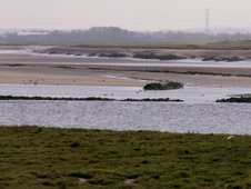
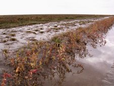
This whole river floodplain is one of Nature's important wetland habitats, with both wetland grazing and drainage culverts offering diverse wetland wildlife habitats...


and a fabulous landscape for us to enjoy!


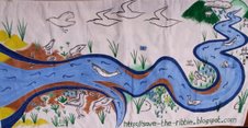
Long Live the Ribble Wild!

savetheribble@tiscali.co.uk

Tuesday 12 June 2007

Ribble ABC

Save The Ribble Campaign are organising a “Ribble ABC” - an alphabet for the Ribble –which will create a picture of distinctiveness about the River Ribble and its local environment.

From Atlantic Salmon and Allotments, Butterflies, Tidal Bore, and Bridges, Cycling and Curlews, Ducks, Dragonflies, and Deep Water, Eels and Evening Primrose, Forget-Me-Nots and Frogs, Gravel and Green Belt, High Tides and Hodder, Incoming Tide and Iris, Jays and Jumping Fish, Kingfishers and Knapweed, Low Tide and Lostock, Mudflats and Meanders, to Nature and Natterjack Toads, Otters and Orchids, Peace and Quiet, Ribble Way and Redshank, Spate Waters, Silts, and Speckled Wood Butterflies, Tides and Tufted Vetch, Undergrowth and Undercurrents, Voles, Willows, eXcitement, Yachting, and Zest, what is it about the Ribble that grabs YOU?


Sparkling Waters bubbling over stones...?


The changing Tides...?


The huge variety of Butterflies...?


The endlessly changing Waters and Silts...?


Walking beneath Beech Trees on the Riverbank...?

Send in YOUR words and pictures which make the Ribble special for you.

Common Ground” are using the ABC format to celebrate “England in Particular” – what makes our local environment special and distinctive – and Save The Ribble's Ribble ABC will follow a similar format, and will be published on the Save The Ribble and The Ribble Cycle Diaries blogs.

In the long term, it may eventually be published as a leaflet. The Ribble ABC will involve both words and pictures, so if you'd like to contribute, or find out more, contact me at savetheribble@tiscali.co.uk and let me know what makes the Ribble special for you.


Saltmarsh on the Estuary...


Green Belt...


Pink Footed Geese...

Common Ground’s “England in Particular” can be viewed online here and their ABC ideas can be seen here, and the importance of our rivers and streams here.


Please contact Jane Brunning at savetheribble@tiscali.co.uk if you would like to contribute to the Ribble ABC, or would like more information.

Wednesday 6 June 2007

May Ribbling in Southport

A May trip to Southport finds a rare sight - the tide is in!


Muddy can't wait to get in that water!

It is already on the turn, however, and goes out as quickly as it comes in across this hugely long but shallow beach. We make it onto the end of the Pier before the waters have receded fully though, and get a clear view right across the Ribble's waters to Blackpool...


Just below the Blackpool seafront, the waves at the edge of the Ribble's main channel can clearly be seen, and the water moving down the channel towards the open sea can be seen moving much more quickly than the receding tide.

There are also a number of ships sailing by...


...and an acrobatic stunt pilot looping the loop over our heads as we stand on Southport Pier...


By the time we get back onto the beach, the tide has almost fully receded, leaving wet sandflats and mudflats, pockets of saltmarsh, and pools everywhere on the flats - which can be treacherous, even walking close to the shore our feet get sucked into the wet sand...


Flocks of birds begin feeding as soon as the tide recedes, the Ribble having replenished the rich silts and nutrients upon which the river's wildlife depends...


...and already the stretch to Blackpool looks deceptively close, almost walkable, the Ribble having retreated to her main channel - which has begun to revert to its old meandering course since dredging the shipping channel to Preston Docks ceased a couple of decades ago.

Some brave souls are happy to follow the river back to her low water mark...


But others, walking the Ribble Way or Trans-Pennine Trail perhaps, stick somewhat closer to shore...


The Ribble is now home to a growing number of walking and cycling routes, many of which are either under construction or have been here for ages and are now being interlinked with one another, providing a fantastic network all along the Ribble from source to the sea, and on both sides:
-the Lancashire Coastal Way (some of which is already open), the North West Coastal Path and the Sefton Coastal Path (again, some already completed), the Regional Coastal Trail, a foot/cycle/bridle bridge over the River Douglas, the Burscough to Banks Wetland Walk, the RCW Regional Park Cycleway, the Fylde Coast Cycleway, Lancashire Cycleway, the Trans Pennine Trail, and the Preston Guild Wheel (which will also link in to several other walking and cycling routes), all linking in with the Ribble Way, the Douglas Way, existing footpath networks, and the Southport to Preston National cycling route. All of these will provide a fantastic contribution to the Ribble Coast & Wetlands Regional Park and will be the ONLY way you can see much of the fantastic scenery, habitats, and wildlife the Ribble supports...

The Trans-Pennine Way Marker at Southport is one of the many interesting sculptures and artworks that line Southport's Promenade...


This unusual species of Southport fish are particularly good...


We walk downriver a little further to one of Southport's many interesting Nature Reserves, part of Southport's contribution to the Regional Park , this one - the Jubilee Trail - is home to Natterjack Toads, though we don't expect to see or hear any as they are usually only active at night!


It is a beautiful Reserve though, ancient dunes which have been colonised by a huge number of native plant species - aswell as Natterjack Toads - and there are wooden walkways across the wetland areas...


...onto the dry...

... a huge variety of plants, wildflowers, and grasses thrive here...


...and the dunes provide a great place for a picninc as well as useful hibernation for the Natterjack Toads!


This was the closest look at an actual Toad that we got, although the dog found something fascinating in the undergrowth nearby so we quickly put her on her lead before she could cause any trouble while we walked along the many paths through this area...


...past Comfrey busily buzzing with bees...


Birds-Foot Trefoil all over the place, nestling amongst numerous plants and grasses...


A rare sight of White Campion, much less commonly seen than the equally beautiful Red...


..and on the way home, an unusual species of bird occupies the roundabout towards Marshside, and watch us as we leave...


Another fantastic day out by the Ribble...

savetheribble@tiscali.co.uk