
The Ribble Way from Gearstones to Horton-in-Ribblesdale.
As we head back up to Ribblehead to begin the second part of our Ribble Way adventures in the first week of September, the weather is considerably less promising than the previous week’s walk to find the source of the Ribble. It is raining quite enthusiastically and the clouds are low and grey, promising neither a pleasurable walk nor spectacular views…
Even as we pass Pendle Hill on our way up the A59, we have to remind ourselves that this significant geological presence IS somewhere beneath a shroud of low cloud which completely hides it from view.
We park one car at Horton-in-Ribblesdale and all squeeze in to the van for the drive up to Gearstones at Ribblehead: the start of stage 2 of our journey down the Ribble Way. On the way up the B6479 we stop at Alum Pot for the first of our planned two diversions (although the day ends with two other unexpected diversions, one of which narrowly avoids resulting in an unpleasant injury of a delicate nature…)
First stop Alum Pot: we pile out of the van and trudge up the path through rain and grey clouds, and half way along I realise my camera is still in the van. I decide not to return to get it, not at all in relief at having thereby avoided the necessity of peering too far over the edge to get a good shot of the drop into the Pot, honest…
It is a pleasant few minutes walk up the track and across the moor to Alum Pot - although the walk introduces us to the first of a series of stile problems which plague us for the rest of the day: the stile here is a narrow stone gap in the wall which the dog is unceremoniously bundled through with much laughter and spraying of pureed sheep poo all over those of us foolish enough to try to help her…
At Alum Pot, the stile is practically non-existent, so the dog is secured to the safe side of the wall and the rest of us clamber over the wall one at a time: the children, the blasé, and the petrified amongst the party warn one another about the steep drop and very slippery rocks and tree roots lining the drop into the Pot…
One by one we edge our way along the lower path to peer into the Pot before realising we’d get a better and safer view from the higher path which follows the wall along to the right, so we all shuffle back again and climb back up to the higher ledge, where we kneel on the roots and cling one at a time to the reassuringly large tree overhanging the drop to peer over as far as we dare. An impressive but wholeheartedly scary sight meets our eyes as the water roars down into the wet, dark and VERY deep chasm below us.
On the way back down to the van we pass a party of cavers heading up to the Pot and congratulate ourselves on our collective and totally sane preference for the freezing wind- and rain-lashed open fells rather than squeezing ourselves into those limestone straightjackets and underground sumps…
That said, we all damply compress ourselves back into the van and head up to Gearstones to park where we left off last week. Voting to picnic in the van before setting off doesn’t make us softies either – we might prefer the great outdoors to squeezing ourselves into tight-fitting limestone coffins in the bowels of the earth but we all stoically endured the ordeal of hard-boiled eggs in a tightly-packed van and emerged blinking into the rain and fresh air feeling we had discovered extra resources in our character we hadn’t realised we possessed.
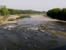
The rain eased off quite a bit as we set off down the Ribble Way from Gearstones, and we quickly arrive at Gayle Beck as it carries on its way to becoming the River Ribble.

Walking across Gayle Beck even at low water below Gearstones is a tricky business as the sculptured limestone rock of the riverbed is treacherously slippery...

...and only after we have safely crawled over by wedging fingers, toes, knees, and teeth into any hand-hold we can do we turn and see the footbridge which crosses over the Beck just a few yards downstream. Well, you can’t SEE the bridge until you’ve crossed over as it’s around the corner of the wall running below the farm. Mind you, it looks a little untrustworthy too, so Ribble Way walkers here are rather stuck between a rickety bridge and a slippery rocky place…
We walk up across and round the Western edges of Thack Pot Ridge and Middle Hill, and the Ribble Way then curves down to what’s left of a small settlement of farm buildings in a beautiful little grove at the Eastern side of High Flat Hill.

It's still wet and overcast, but the fells look beautiful whatever the weather...


and you get a good view of the viaduct from this first section of the journey.
Most of the buildings near high Flat Hill have pretty much fallen into rubble although those which still have walls and roofs look to have been in use in more recent decades. Here the Ribble Way takes a sharp turn to the South East at the side of the first building on the left, but we are heading straight-on Westwards for our second planned diversion from the Ribble Way…

...which gives glimpses of Whernside when the low cloud allows it!
Following the footpath which heads full West to cross Gayle Beck here, we pass to the North of High Flat Hill and cross what is initially rolling green moor strewn with sheep and the remains of several old buildings before it becomes rolling green moor strewn with incongruous limestone boulders, left here for us to marvel over by the last glacier to pass this way…

Continuing to head West, we reach Gayle Beck after only half a mile where the footpath is carried over the water by the remaining small stone arch of a tiny footbridge, perched impossibly in the air above the Beck.


Gayle Beck has cut a fantastic gorge through the limestone rocks here, giving pause for thought about the forces of the Ribble’s waters even at this early stage in its life – before it is even officially named the Ribble proper.

We leave the footpath and follow the Beck further downstream a few metres until it finds its way out of the gorge onto the valley bottom.

Gayle Beck emerges into a wide and very deep pool -

-which Muddy just can't resist!
This is just below Ribble Head House, about a mile away from the old Ribblehead settlement, and we feel we can’t be alone in seeing this water as the beginning of the River Ribble proper as it flows out from its limestone gorge into the river valley which opens out before it…

We spend a good while exploring and marvelling over the area before we head back the way we came to rejoin the Ribble Way once more…
It is a great shame that the Ribble Way doesn’t follow this route as the gorge and Gayle Beck/the Ribble here at Ribblehead is truly beautiful, and well worth a diversion.
Back on the Ribble Way, it now passes in a South-Easterly direction across Back Hools Hill, Thorns Moss, and below Crutchin Gill Rigg and Lings Gill Rigg to Nether Lodge, with our party having to negotiate a number of difficult stiles as well as good map-reading skills due to the lack of Ribble Way signs and obvious stiles along the way.
We find ourselves playing Spot The Ribble from here on as the River Ribble (in pre-pubescent Gayle Beck form or otherwise) proves a rare sight for the rest of the day as the Ribble Way leaves the water behind to scale the heights of the Western moors of Plover Hill and Pen-y-ghent.
The party have mixed feelings about the Ribble Way leaving the waters we have come to explore so far behind them on some parts of our route – and for the vast majority of today’s journey! Some of us feel that it is nowt but an irritation to be diverted up hill and over dale (not to mention over the most awkward stiles ever devised by mischievous imps who clearly wish nothing more than an overwhelming urge that none shall pass!) whilst some of the party feel the Ribble Way necessarily includes the Ribble valley... and it is true that passing across the fells all along the Ribble Way from Gearstones to Horton we do get some spectacular views – even despite the less-than-perfect weather…

The Ribble - as Gayle Beck still - makes its way down the valley...

...towards Selside and its meeting with Cam Beck...

...running between Pen-y-ghent...

...and Ingleborough.
At Nether Lodge the welcome sight of Cam Beck with a nice new footbridge crossing is a relief to us as well as the dog, who is doubtless as fed up at the unceremonious heaving over and through numerous unfriendly stiles as we are fed up with having to stagger up and over everything from 2 metre high over-wall ladder stiles to rickety wire-covered wooden structures whilst clutching walking sticks and heavy wet dog.

Why are most of the gates padlocked? Why do none of the stiles have dog-friendly access? Why do none of the stiles have dodgy-knee-with-a-walking-stick friendly access???
Unfortunately access problems are about to get a lot worse…
We cross Cam Beck (which appears to undergo an identity crisis according to the map as it flows down from Cam Fell as Cam Beck, disappears underground North-East of Nether Lodge where it appears to become Ling Gill Beck, before becoming Cam Beck once more somewhere around Nether Lodge…) and head up the well-gravelled path across Cow Close towards God’s Bridge… little realising just how Close those "cows" will be!
As we approach the crest of the moor just before Brow Gill Beck, we hear a loud bellowing from up ahead which becomes louder and rather more intimidating as we grow steadily nearer and nearer… then as we reach the crest we all stop dead as one, stopped in our tracks by the somewhat intimidating sight of 2 huge bulls, one of which is bellowing and charging around in a rather disconcerting fashion. After several minutes wondering whether it’s possible – let alone wise! – to attempt to negotiate a safe passage, and having visions of having to flap the map like a matador’s cape at the bull while everyone else legs it, we reluctantly but sensibly turn back towards Nether Lodge.
Here we take what turns out to be an initially very pleasant if unplanned detour, following Cam Beck as it flows South to meet Gayle Beck and officially become the Ribble at last…

…but this week we do not pass as far down as the Ribble, but follow Cam Beck for over a mile as it wends its way before our footpath curves away from Cam Beck towards Coppy Gill.
At Coppy Gill we turn North-East and follow the footpath up to High Birkwith to rejoin the Ribble Way below Dismal Hill.
Some aspects of this part of our journey become very Dismal indeed as this section from Coppy Gill to above High Birkwith proves to be “interesting” for all the wrong reasons…
First of all, an adult in the party, whose life-time ambition of keeping all his bodily parts well and truly attached nearly came a cropper when the stile crossing the wire fence just below High Birkwith proved to be completely unattached to its frame, collapsing beneath him and bringing the wire of said fence uncomfortably close…

Then a 10 year old in the party had her life-time’s ambition to see a fox in the wild fulfilled in the worst possible way as we were met with the sight of a beautiful young fox strung up on the gate at High Birkwith.
Dismal Hill began to feel really dismal...

...and to cap it all, our relief at rejoining the Ribble Way just below Dismal Hill also suffered a set-back as the route did not appear to be signposted and we found ourselves heading East towards Birkwith Moor instead of South along the Ribble Way.
So after negotiating a crossing over the deeply-crevassed limestone pavement South of Dismal Hill (yes, having to carry the rusty-hipped dog part of the way), we finally found ourselves back on the Ribble Way.

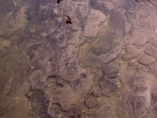
Fantastic limestone pavement though...
The views of the valley from up here really are excellent, Pen-y-ghent looking very intimidating indeed from up here –

- although we are still limited to very occasional and very brief glimpses of the Ribble far away below us, and can only see it well through the zoom lens (and it IS the Ribble now, of course, whether you take the confluence of the Gayle and Cam Becks at Selside or the emergence of Gayle Beck at Ribblehead to be where the River Ribble begins her adult journey.)

We suffer yet more inaccessible stiles, although the further we get, the more gates we find helpfully NOT padlocked, and we enjoy the sights of the fells, the occasional spring...

...and even a rabbit determined not to be put off the best patch of grass on the whole fell by us…

Am I bovvered?
..as well as a glimpse of The Tarn on the valley bottom, meaning we are exactly opposite Alum Pot on the far side of the valley…

…and as we slowly descend, the glimpses of the Ribble become slightly more frequent, and we eventually join the Pennine Way (and the first Ribble Way marker we have seen since entering the Ribble Way at Gearstones hours ago!) which passes by Sell Gill Holes and a couple of intrepid cavers getting all their ropes and kit on ready for a descent into the gloomy depths below…

… how weird out on the wide-open and scarcely populated fells to think that there are lots of people crawling through the limestone beneath our feet…
As we descend more steeply towards Horton-in-Ribblesdale, the valley becomes greener and less wild...

...with Spot the Ribble becoming much easier to play…

…and the quarry, seen from as far away behind us as Cam Fell, looms ever larger over the village…

…although the abundance of wildflowers is a more pleasant sight!


The view of Pen-y-ghent as we arrive at Horton is an impressive sight...

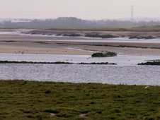
...and as we finally reach Horton-in-Ribblesdale, approximately an 8 mile trip today including diversions (planned and otherwise), the sight of the River Ribble running through the village is well-worth the journey!

The Ribble is joined by Brant’s Gill at Horton...

... and looks so familiarly the Ribble already, wending its way through the trees and across the pebbles of the riverbed…

…as it heads down the valley towards Stainforth…

...and the next part of our journey.
Next week, we will walk from Horton to Stainforth, taking in yet another diversion along the way: a trip down to the confluence of Gayle Beck and Cam Beck at Selside: the “official” start of the River Ribble proper – although today’s diversion to where Gayle Beck emerges out of her limestone gorge at Ribblehead has convinced us that the Ribble reaches her incarnation as the River Ribble at that point, but we will see if Selside persuades us otherwise.

An old dog has had enough for one day...
You can read our next installment, The Ribble Way Part 3, Horton to Stainforth;
and the beginning of our Ribble Way adventures where, in Part 1, we explore the source of the Ribble on Cam Fell.
You can contact me at savetheribble@tiscali.co.uk


No comments:
Post a Comment